
Projects
Watershed Projects Preserve Water Quality
There are numerous factors that affect water quality in the Chatfield Reservoir, with some having a larger impact. As the uses of the reservoir change, and the growth of the urban areas continue, so does the impact of pollution. Projects preserve water quality in the Chatfield watershed and reservoir. Projects address:
Agricultural Activities
Septic Systems
Streambank Stabilization
Wildfire Management
Water Quality and Habitat Improvements
Plum Creek Water Monitoring
Projects
2025
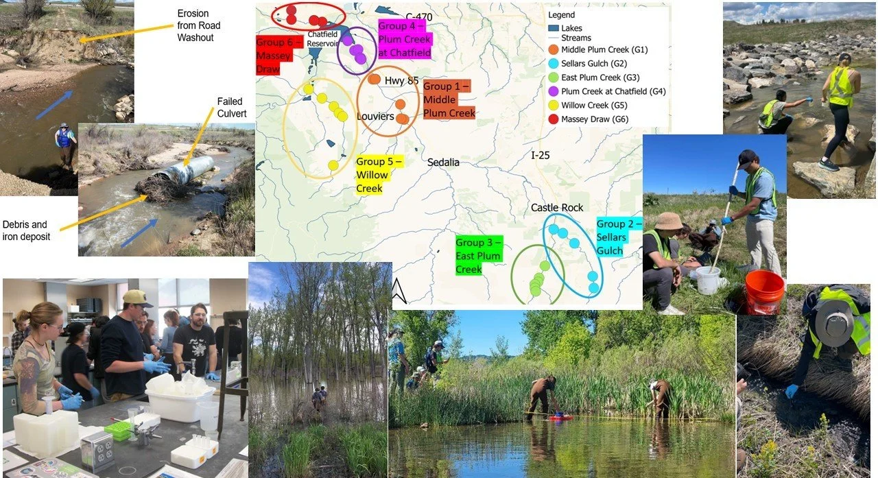
2025 Colorado School of Mines Chatfield Watershed Field Session
Environmental Engineering Field Session: Threat-based Management for Creeks, Streams, and Rivers
The below information is provided for reference only. The sampling results and conclusions have not been reviewed or verified by the CWA.

General Objectives:
Measure and evaluate the water quality
Assess various ecological conditions to classify stream health
Measure and gauge streamflow to calculate pollutant loadings
Evaluate the impacts of surrounding site land use and site geology on water quality
Identify various ecological risk factors
Compare the results to water quality standards and past historical data

Group 1 - Deer Creek 2025
Group 2 - Sellars Gulch 2025
Group 3 - East Plum Creek 2025
Group 4 - Plum Creek at Chatfield Reservoir 2025
Group 5 - Willow Creek 2025
Group 6 - Massey Draw 2025
Projects
2024
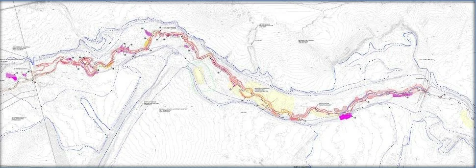
Quarry Fire


Map of Quarry Fire and Mitigation Study Area
Colorado School of Mines: Quarry Fire Mitigation Study Following the Quarry Fire
The Authority engaged with a group of CSM seniors to design solutions intended to reduce the negative water quality impacts from runoff from the fire on Deer Creek and Chatfield Reservoir. A successful solution will reduce the expected increase in sediment transport and nutrients from the burn area runoff to help protect the beneficial uses of Chatfield Reservoir and Deer Creek. The design solutions may include some of the following: debris basins, sediment control facilities, wetland filters, beaver dam analogs, stream restoration, and other applicable water quality improvement measures. The students submitted a preliminary design in October, which included filtration socks and a sediment pond. Their final design was submitted in May 2025.
The Quarry Fire started on July 31 and burned through the first week of August. This wildfire burned approximately 579 acres in Deer Creek Canyon. The fire threatened more than 750 homes and other structures in the area. The fire is believed to have been human-caused and is being investigated for arson. With so many homes at risk, FEMA approved a Fire Management Assistance Grant. This grant made funding available for 75% of the costs for managing, mitigating, and controlling the fire. Approval of the Fire Management Assistance Grant makes the other funding available for use post-fire. The Deer Creek Mesa, Kuehster, McKinney Ranch, Murphy Gulch, Sampson, and Maxwell neighborhoods were evacuated, emptying 600 homes. No homes or other structures were reported to be burned, but the fire came within a quarter mile of some homes.
At the peak of the fire on August 2, 225 firefighters worked the line. Five firefighters were injured during the week spent containing the fire. In addition to firefighters on the ground, aircraft were employed to control the burn. The aircraft made many trips from the Chatfield Reservoir to the fire, scooping water to control the flames. About 100,000 gallons of flame retardant were used on about 50 acres of the burn area to suppress the fire and minimize the risk of the fire moving into residential neighborhoods.
The Authority understands that flame retardant has typical properties of about 85% water, 10% ammonium phosphate fertilizer, and 5% other ingredients like colorant, corrosion inhibitors, and stabilizers. The ammonium phosphate fertilizer and other ingredients are a water quality concern. The Authority in partnership with the Colorado School of Mines (CSM) are looking into potential permanent water quality control measures that can be implemented in the watershed to reduce the impacts of the fire and fire retardant downstream of the burn area and to Chatfield Reservoir.
Chatfield State Park Tree Removal

Chatfield Reservoir Aerial Tree Removal
The Chatfield Storage Reallocation Project (CSRP) started 2024 by maintaining its water storage capacity, in large part due to high precipitation totals and cool weather in 2023. The sustained high-water levels contributed to a decline in tree health, creating increased hazard potential for park visitors. CRMC’s environmental specialists conduct annual tree surveys of the park and identify cottonwoods and willows in the fluctuation area of the reservoir that are dead or in declining condition. The loss of trees was anticipated and accounted for through the CSRP's environmental mitigation projects, which included proactively planting trees in 2018 to offset such loss in habitat. An estimated 100,000 trees and shrubs were planted within the park. The 2024 tree removal effort aimed to remove as many dead and declining trees in areas that have experienced longer sustained inundation.

Chatfield Reservoir Aerial Tree Removal
Beginning in October 2024, Chatfield State Park estimated around 2,700 trees could be removed from the reservoir. Most of the trees were removed by a ground crew or by the use of a logging helicopter outfitted to cut and haul the trees. The use of aerial operations was integral to safely and efficiently completing the work over the winter months. The removed trees will be repurposed for mulch and stream stabilization. An additional round of tree removal on the east side of the park is currently slated for late fall 2025.
Douglas County Sugar Creek Offsite Mitigation Project

Maintenance conducted on a sediment trap
The Sugar Creek project is located 19 miles upstream of the Reservoir along 4.5 miles of Douglas County South Hwy 67 (Sugar Creek) within the Pike National Forest. Douglas County took over maintenance of the Sugar Creek Road improvements from the Chatfield Reservoir Mitigation Company in August of 2022. Douglas County subsequently collaborated with a contractor to perform maintenance on the sediment traps which are a unique component of the Sugar Creek sediment transport mitigation infrastructure. 29 cubic yards of sediment were removed from the sediment traps in 2024
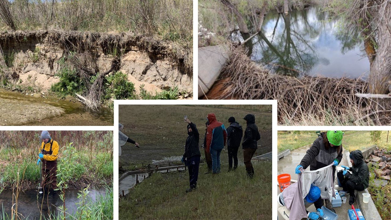
Colorado School of Mines Chatfield Watershed Field Session 2024
Environmental Engineering Field Session: Threat-based Management for Creeks, Streams, and Rivers
GENERAL OBJECTIVES:
The below information is provided for reference only. The sampling results and conclusions have not been reviewed or verified by the CWA.
Group 1: Middle Plum Creek - Findings & Recommendations
Group 2: Sellars Gulch - Findings & Recommendations
Group 3: East Plum Creek at Lowell Ranch - Findings & Recommendations
Group 4: Plum Creek at Chatfield Reservoir - Findings & Recommendations
Group 5: Willow Creek - Findings & Recommendations
Group 6: Massey Draw - Findings & Recommendations
Investigate sites to create a real time snapshot of water quality in Chatfield watershed tributaries via various water quality parameters and soil leachate samples
Conduct assessment of the ecological state of field sites
Measure hydrologic aspects of tributaries
Investigate risk factors
Projects
2023
Spring Up the Creek - Town of Castle Rock

A tradition for Castle Rock that draws residents every year to preserve our waterways by removing trash that collects along the stream banks. The event occurred on Saturday, May 5, 2023. More than 207 volunteers picked up 162 bags of trash along 9 designated trails. Volunteers assembled at specific trailheads across the town. Castle Rock Water, Castle Pines Metropolitan District, Plum Creek Water Reclamation Authority, Chatfield Watershed Authority and Douglas County sponsored the event. This year’s give‐away was seed bombs. These tiny balls are laden with Colorado native wildflower seeds and provide a fun opportunity to throw them along paths, in yards or in other open spaces.
East Plum Creek Stabilization Project
Douglas County Special Projects group continued work on the East Plum Creek stabilization project in coordination with CALF and a variety of constituents. Work included bank stabilization, vegetation planting, and clean-up work following two intense flow events that occurred in the spring of 2023. The work within the project area did survive the intense flows, substantiating the credibility of the stabilization approach and methods. Work is estimated to be complete in the fall of 2024.

East Plum Creek Reach 6 Stabilization Town of Castle Rock
Castle Rock Water completed stream stabilization of Reach 6 along East Plum Creek. East Plum Creek is the largest drainageway within the Town and is located on the western side of Town. Stream stabilization occurred in five locations, three being drop structures and two being bank protection, with a total channel length of approximately 3,700 lineal feet. Work included grading the incised channel banks, reconstructing the channel bed, placing buried riprap to protect channel banks, installing sheet pile cutoff walls, installing riffle drops and cascading boulder structures, and planting native grass and willows. Stream stabilization efforts such as these support the mission to preserve and protect water quality within the Town’s open space and the watershed. Construction kicked off in February 2023 and is now substantially complete, except for willow planting to be done in spring of 2024. The contractor was 53 Corporation, Inc. The construction cost was $1,353,006, and the project was completed under budget and on time.
Colorado School of Mines Chatfield Watershed Field Session 2023

Overarching goals for the session:
1. Obtain and document a snapshot-in time of water quality in the Chatfield watershed tributary creeks through sampling and testing of water quality parameters of concern and streamflow rates.
2. Interpret the potential linkages between the watershed soils/geology/land uses on the sampled water quality constituents.
3. Provide advice on possible measures to improve the quality of water in the Chatfield watershed.
4. Report and present findings to representatives of the Authority.

Red Rocks Reservoir and Upper West Plum Creek - Findings and Recommendations
Jackson Creek & West Plum Creek - Findings and Recommendations
East Plum Creek at Lowell Ranch - Findings and Recommendations
Plum Creek at Chatfield Reservoir - Findings and Recommendations
Willow Creek & Deer Creek - Findings and Recommendations
Massey Draw - Findings and Recommendations
Projects
2022
Douglas County Willow Creek Stream Improvements at Sterling Ranch
Construction of the Willow Creek Stream Improvements at Sterling Ranch project started in October 2021 and concluded in February 2022. The large-scale project has restored a section of Willow Creek upstream of Chatfield Reservoir. Sponsored by the Sterling Ranch Community Authority Board, the Mile High Flood District, and Douglas County; the stream-restoration project rehabilitated nearly 1-mile of stream channel, riparian habitat and floodplain between Rampart Range Road and Waterton Road.
Prior to the project, the Willow Creek corridor was highly degraded. Eroding streambanks contributed large quantities of sediment to downstream receiving waterbodies. Wetland habitat and floodplain connectivity was deficient due to the incised nature of the channel. Residential development projects planned for the watershed would be contributing additional stormwater volume to Willow Creek, increasing stress on the natural system. Restoration and stabilization of the creek was necessary.
Outcomes of the completed project include:
Realigning and stabilizing 8,600 linear feet of streambank
Constructing 33 riffle-pool stream features
Planting 55 acres of native plant seed
Planting 50 trees and nearly 2,000 shrubs
Establishing 2 new acres of wetland habitat
Creating 18 acres of high-quality riparian habitat
Establishing a high functioning and more resilient stream corridor
East Plum Creek Restoration Partnership

Click for more information on the East Plum Creek Restoration Partnership.
The Douglas County Conservation District received a $19,935.00 grant from the Colorado Healthy Rivers Fund for the East Plum Creek Restoration Partnership (EPCRP) located at the Colorado Agricultural Leadership Foundation’s (CALF) Historic Lowell Ranch in southern Castle Rock, Douglas County. CALF owns the 168-acre property, and the entire stream restoration project is approximately a 1-mile long riparian corridor containing East Plum Creek. The property has a conservation easement held by Douglas Land Conservancy in perpetuity. This project is an important link to reduce the fragmentation and connect a variety of protected habitats both upstream and downstream of the project. The District in collaboration with project sponsors will work with contractors to continue the successful restoration practices implemented, which include more economical and less disruptive bank-focused lay back and stabilization methods to address bank wasting and the incised channel at the East Plum Creek Restoration Partnership. Once completed a breeding habitat will be created for waterfowl and improved habitat for a variety of Priority Wildlife Species, including beaver with the implementation of diverse plantings, woody debris and drop structures. The habitat improvement for native aquatic invertebrates, fish and amphibians will be specifically targeted as well. This project is an important link to reduce fragmentation and connect a variety of protected habitats both upstream and downstream of the project within this important wildlife corridor.
Sugar Creek Offsite Mitigation Project

Sugar Creek project is located 19 miles upstream of the Reservoir along 4.5 miles of Douglas County South Hwy 67 (Sugar Creek) within the Pike National Forest. Douglas County took over maintenance of the Sugar Creek Rd. improvements from the Chatfield Mitigation Company in August of 2022. Douglas County subsequently worked with a contractor to perform maintenance on the sediment traps which are a unique component of the Sugar Creek sediment transport mitigation infrastructure. Over 50 cubic yards of sediment were removed from 34 sediment traps.
Craig & Gould North Infrastructure Improvement Project

In collaboration with the Authority, Castle Rock Water is managing several current and proposed drainageway improvements along East and West Plum Creek. These projects enhance and, in some cases, reconstruct the natural floodplains in the Town of Castle Rock. This infrastructure serves to reduce public risk from stream channel erosion and flooding. These projects also have a water quality component that ensures our renewable drinking water supplies are preserved and protected.
The objectives of the Project were to add storm sewer within the public right-of-way to capture stormwater runoff, replace aging water and sewer infrastructure and upgrade the streets to current residential standards for safety. This includes two travel lanes on all residential streets, parking lanes, curb, gutter and sidewalks throughout the majority of the project. Existing alleyways that remained dirt up to this point were paved with concrete. In order to convey stormwater runoff, an outfall system was needed crossing the railroad. This outfall includes an underground water quality chamber to remove pollutants prior to discharging to East Plum Creek.
Construction began in November 2021 and will be completed no later than August 2023. JBS Pipeline, LLC was contracted by the Town to construct the project. Funding is provided by Castle Rock Water and Public Works, with a construction budget of $7.6 million. All properties within the project limits received new service line connections for water and sewer up to the property line. All water services were checked and determined not to have lead piping. Should this have been identified, lead piping services would have been replaced up to the house.
Omni Tributary: Prairie Hawk Drive to Red Hawk Drive
This project consisted of Stormwater Master Plan improvements for the Omni Tributary drainageway between Prairie Hawk Drive and Red Hawk Drive to repair damage to the channel as a result of development runoff, reduce flood risk to adjacent residential properties, decrease sediment transport downstream, and prevent further loss of existing vegetation and trees to the maximum extent possible. Additional channel stabilization measures are also included along the nearby Unnamed Tributary adjacent to Red Hawk Ridge Golf Course Hole No. 6.
Drainageway improvements on Omni Tributary consisted of importing and placing approximately 2,000 CY of fill material and 2,470 CY of topsoil, construction of five grouted boulder drop structures, and installation of riprap at various locations for culvert outlet protection and bank stabilization. Additionally, seven deciduous and fifteen evergreen trees will be planted at the end of the project to offset some of those lost during construction.

On Unnamed Tributary the scope of work is similar, with construction of one grouted boulder drop structure, riprap installed for bank stabilization and a steel sheet pile cutoff wall added to control the channel slope. Additionally, an existing triple 30” corrugated metal pipe crossing of a neighborhood paved trail was replaced with reinforced concrete pipe and new metal handrails for safety, and an existing raw water line crossing the channel was protected by raising the invert to provide more cover.
The contractor was 53 Corporation, LLC. The cost was $1,345,275, and the project was completed under budget. The project was completed in October 2022.
Colorado School of Mines Civil and Environmental Engineering Department Field Session
The Colorado School of Mines Civil and Environmental Engineering Department Field Session activities took place during the time period from May 16, 2022, through June 3, 2022. During the Environmental Field Session for 2022, students collected water quality data for the Chatfield Watershed Authority in order to determine whether surface water bodies such as streams and lakes meet the requirements set forth by the Colorado Department of Public Health and Environment (CDPHE). This field session is conducted like a real-life consulting project in which the Colorado School of Mines students serve as the environmental consultants delivering assessments on projects for the Chatfield Watershed Authority. Objectives were developed to be met for each of the six study sites identified for the field session. There were overall objectives for the session and site-specific objectives for each field location.

East Plum Creek - Key Findings and Recommendations
West Plum Creek and Tributaries - Key Findings and Recommendations
I-25 (East Plum Creek along I-25) - Key Findings and Recommendations
Sellers Gulch - Key Findings and Recommendations
Sterling Gulch & Willow Creek - Key Findings and Recommendations
Deer Creek - Key Findings and Recommendations
OBJECTIVES
1.Determine if there are any exceedances of Colorado 303 regulatory limits at study sites. Special emphasis given to arsenic, phosphorous, selenium, and E. coli.
2.Note the surrounding land uses (via field observation and investigations in Google Earth) and identify the potential for those land uses to contribute to water quality impairment.
3.Note and investigate any curious structures, operations, or formations near your study sites.
4.If illicit drainages are found, fill out an assessment sheet on the feature and if possible, perform water collection.
5.Investigate the local geology in the area to see if any formation outcrops could be contributing contaminants to receiving waters.
6.Evaluate and sample eroded streambanks and sediments, and perform leaching studies to determine what constituents of concern may be released from sediments during a flood event.
7.Where no water present, sample and test the sediments in the dry streambed for indications of what would be in the water if it were present.
8.For the snapshot period of the morning of May 20th, measure flow rates and compute contaminant loadings. Emphasis on loadings will be given to arsenic, selenium, phosphorous, and suspended solids.
West Plum Creek Stream Management Plan

Click image to access the draft report.
West Plum Creek is the last relatively unaltered transition zone stream in the area and is home to several important plains fish species. The resident fish in West Plum Creek are the only surviving relicts of declining plains species native to the South Platte and Arkansas River basins. Colorado Parks and Wildlife, alongside partners including US Fish and Wildlife Service, Douglas County Open Space, Chatfield Watershed Authority, and River Network, support an effort to study and assess aquatic and riparian habitat, as well as better understand hydrology and opportunities in water management with the water users. The end goal is to implement conservation actions that a diverse stakeholder group can support to help protect these fish (e.g., improving fish passage, enhancing water quality, and supporting healthy riparian conditions, as well as exploring potential opportunities for water management and flow protection).
Chatfield Storage Reallocation Project
In addition to flood control, Chatfield Reservoir recently added drinking water storage to its purpose. With the growing demand for water in Colorado’s Front Range and northeast Colorado farms, the U.S. Army Corps of Engineers (Corps) approved expanding the reservoir by 20,600 acre-feet for drinking water. The Chatfield Storage Reallocation Project, completed in 2019, required modifications for the recreational components of the park and environmental mitigation to restore and enhance the wildlife habitat.The Authority is currently monitoring water quality data and analyzing the changes occurring from additional water flow through the watershed and into the reservoir.
Plum Creek Streambank Stabilization
In collaboration with the Authority, Castle Rock Water is managing several current and proposed drainageway improvements along East and West Plum Creek. These projects enhance and, in some cases, reconstruct the natural floodplains in the Town of Castle Rock. This infrastructure serves to reduce public risk from stream channel erosion and flooding. These projects also have a water quality component that ensures our renewable drinking water supplies are preserved and protected.